Jessica Kieras - Waldo Lake
Loop around North Isl, Rhododendron Isl, South Isl via Shadow Bay
20.8 km (12.9 miles)
6 hours, 54 minutes on 24 July 2021
Observed and documented by Mary Louise Warhus
First documented swim

Contents
Swimmer
- Name: Jessica Kieras
- Gender: female
- Age on swim date: 41
- Nationality: United States
- Resides: Redmond, Oregon
Support Personnel
- Daniel Baugher - kayaker
- Mary Louise Warhus - observer
Observer experience: Observer for Lake Billy Chinook documented swim 2020.
Escort Vessel
| Name | Type | Port |
|---|---|---|
| Blue Donkey | tandem sit-on-top kayak |
Swim Parameters
- Category: Solo, nonstop, unassisted.
- Rules: MSF Rules of Marathon Swimming, without exception or modification.
- Equipment used: Textile swimsuit (TYR tieback), silicone cap, swedish goggles, ear plugs, Desitin.
Route Definition
Island-delimited loop around perimeter of Waldo Lake: Shadow Bay Boat Ramp to North Island to Rhododendron Island to South Island to Shadow Bay Boat Ramp.
- Body of Water: Waldo Lake, Oregon
- Route Type: multi-island loop
- Start & Finish location: Shadow Bay Day Use Boat Ramp (43.691805 N, 122.043600 W)
- Intermediate Waypoints
- North Island: 43.75988N 122.00736W
- Rhododendron Island: 43.71855N 122.05547W
- South Island: 43.68210N 122.05291W
- Minimum Route Distance: 20.8 km (12.9 miles) (map)
History
I first did this route as an unofficial 'adventure swim' in August, 2018 and did it again in August 2019. I have not heard of anyone doing it before or since. Oregonians treasure Waldo Lake as a swimming spot, but the favored route is from Shadow Bay, to Rhododendron Island and back, typically done in full wetsuits. I have also heard of several swimmers who’ve gone from Shadow Bay to the North Island as a one-way.
Swim Data
- Start: 24 July 2021, 07:58:43 (Pacific Daylight (America/Los_Angeles), UTC-7).
- Finish: 24 July 2021, 14:53:02
- Elapsed: 6 hours, 54 minutes, 19 seconds.
Summary of Conditions
| Feature | Min | Max |
|---|---|---|
| Water Temp (F) | 64.8 | 67.7 |
| Air Temp (F) | 69.1 | 91.1 |
| Wind (knots) | 0 | 5.7 |
GPS Track
Trackpoint frequency: 5 minutes. Download raw data (CSV). Note: the final ~95 minutes of swim are without tracking data due to device failure.
Speed Plot

Nutrition: Infinit “endurance blend” every 20 minutes, substituting coca cola and a mocha (starbucks via+starbucks dark chocolate powder) as treats in second part of swim.
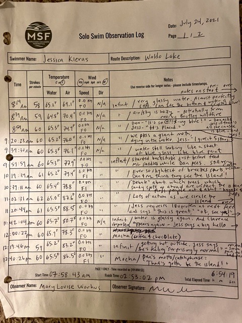
Observer Log


Narrative
Also see: Oregon Lake Bagging: A Tour of Three Islands
What inspired you to do this swim?
A number of things inspired me to do this swim, but it all really just comes down to the lake itself. Waldo Lake is an ultraoligotrophic lake, meaning it is exceptionally clear, with almost no dissolved nutrients. The result is breathtaking visibility around 130 feet, which means you can see every detail of the bottom as you swim out away from shore. “Alpine Tropical,” my friend calls it. Once you get out there, you just see an abyss of cobalt blue, sometimes with white beams of light stretching down below you. People are surprisingly scarce once you get beyond a quarter mile or so from any of the lake’s three campgrounds, which are the only development anywhere nearby. Oregonian conservationists are so serious about keeping this place clean and wild that all human waste is pumped out of the out-houses to be disposed of off-site. Gas powered motor boats were outlawed in 2012, so the only lake recreators are swimmers, paddlers and small sailboaters. Water temperatures range from high 50s to mid 60s July through mid-September and are affected by the air temperature along with wind, which stirs cooler water to the surface from below. August and early September are the best months to visit, because the legendary swarms of mosquitos are mostly gone by then. The elevation is 5400 feet and on a clear day, a swimmer can enjoy beautiful mountain views during feed breaks. Rarely in today’s highly developed, populated and polluted world, can a swimmer experience this incredible solitude in such a large body of water.
Describe how you planned for the swim
In a way, I planned for the swim over a period of years and practice swims. I did the whole route once in 2017 and another time, as a part of a longer training swim in 2019. I didn’t document either swim, but wrote about them in my blog. I didn’t know how to recruit or train an observer yet, so they were just “adventure swims”. I had read about “repeatable routes” on the msf forum and Evan Morrison’s website, so I understood the concept and thought the lake’s three islands would make a neat, geographical constrained route. Once I knew more about how swims are documented, I thought it would be nice to establish a route here in the hopes of other swimmers coming to enjoy the lake.
There is no cell service at the lake, but the gps function on my phone and watch still worked fine. My spot tracker failed part way through. I created a gps track of the route on my phone for my kayaker, Dan to follow as he navigated. While he found it helpful, the dot is not always exactly where it shows up on the map. For that reason, it was helpful to have done the route (and parts of the route) several times before (one time getting lost), so that we knew what to look for. I’ve included some landmarks to site off of in the narrative below.
How did the swim go, generally? Did you face any unanticipated challenges?
The swim went amazingly well. The water was glassy, nearly the entire way and I was incredibly happy to be there.
[Shadow Bay to North Island]
My teeth chattered for the first few minutes due to excitement and nerves. Then I settled into a nice rhythm and felt very comfortable as I marveled at the beautiful, blue water, which never gets old. This section passed without incident. Dan and ML did well working together as a team in the tandem kayak, with Dan paddling in the back and ML sitting in front, free to take measurements and write notes. She wrote in a “Rite in the Rain” waterproof notebook and later transcribed her notes onto the regular paper MSF log form. She highly recommends this tool for anyone kayak observing, especially someone like me with a heavy, splashy kick. As I swam, I recognized some of the landmarks along the way: After leaving the inlet, we headed for the furthest point jutting out from the east side of the lake. We continued north, parallel to the east shore, eventually passing Islet campground as we neared the north end of the lake. The Northern Island is recognizable by the people that congregate there. We headed for the people and I swam around the island, utilizing breaststroke and backstroke to avoid running into the shallow bottom.
[North Island to Rhododendron Island]
As we headed south, Dan aimed for the western side of what we call “the pinch point” of the lake, where the lake is at its most narrow. Rhododendron Island is very close to that western point, which is visible from the north end of the lake. During a feed, Dan and ML pointed behind us and I saw a red kayak gaining on us, coming from the northern island. It was a friend of ours who had spotted Dan while we were going around the northern island. We were really excited because we didn’t expect to see him there! In fact, we hadn’t seen him in years, but he was a good friend of ours, who played bass in a band we were in together once upon a time. He paddled on my left, while Dan and ML stayed to my right. It was so fun seeing someone I hadn’t seen forever in that context, but slightly awkward that I didn’t feel like stopping to chat. I had to keep swimming! He eventually disappeared, and I learned on the next feed he had gone back to his camp. Dan confessed he had been somewhat distracted while catching up and had gotten off course. He didn’t know how far off and I did my best to pretend I wasn’t a little disappointed.
[Rhododendron Island to Southern Island]
We made it to Rhododendron Island and for a bit I reflected on my gratitude to be there, something I find helpful to do during long swims. A friend of mine and I had swum out to the island a month prior and I had relied on one arm freestyle, backstroke and kicking to get me there and back due to a shoulder problem I had. Now here I was, two arms, both of them feeling very strong with the familiar and healthy pain sensation that comes on long swims. I smiled and swam out of the shallow water and back into the deep blue.
At this point, we headed due south, sighting off the valley in between the two highest hills on the southern horizon. Just then a little southwest wind picked up and the water seemed a lot more like the Waldo I know and love. I bounced around and thought, this is such good practice for windy swims. I drank some coca cola and got super giddy, exclaiming my joy at the headwind, of all things. ML said it was the happiest she’s ever seen me while swimming.
I could tell by looking over at the kayak that there was some discussion as to where we were headed, based on the monitoring of the gps and the arm pointing that was happening. The southern island is hard to spot and the gps was showing something different than where Dan remembered the island to be. In the end, Dan’s recollection was accurate and we got there just fine. My mood had soured, however, for no particular reason other than that the coke was wearing off and the swim was about to be over and that brought up all sorts of things. After rounding the island, I knew exactly where were were. So did Dan, as this is where we had gotten lost on a practice swim. The boat ramp is not visible from the main part of the lake and is very easy to miss. Knowing this, Dan paddled us parallel to the southeastern shore, into the inlet and finally to the boat ramp for a successful finish.
See also, https://oregonlakebagging.wordpress.com/2021/07/25/waldo-lake-a-tour-of-three-islands/ for a more lengthy report.